
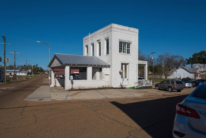
 This unpretentious little piece of real estate on the east side of downtown Natchez occupies a triangular section where M L King (formerly Pine) Street intersects with St. Catherine Street and Jefferson Street. This area has long been known as the “Triangle” and was home to Burns’ Bakery in 1876. Today, the Triangle is a key location in the proposed redevelopment of the downtown district in Natchez.
As early as 1905, an item appeared in the news that residents had requested a street light for illumination of the southern leg of St. Catherine (visible in the shadow obscuring the street above) due to the many accidents cited as vehicles turned onto Pine Street.
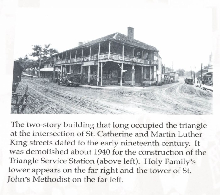
 The second photograph from the left, top row of the Natchez Trails Views of St. Catherine Street-Western End is the building that occupied the triangle prior to the construction of the Triangle Service Station, c. 1926-1940. A crop of the photograph reveals one business occupying the triangle building at the time of this photograph (in the early 20s based on car design) was Scotts Grocery.
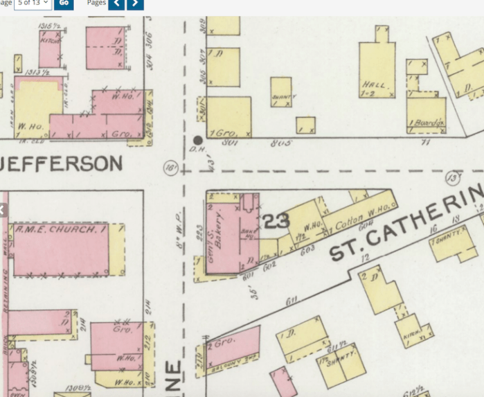
 Burns listed his Pine Street Store for sale for $5,000 in 1919, and included a “large cotton shed” as well as the store and upstairs, both of which were rented (Natchez Democrat, Apr. 30, 1919, p. 9). The 1886 Sanborn map below shows the early buildings behind the Burns Bakery, which were removed and replaced by the cotton warehouse mentioned in Burns’ for sale advertisement in 1919.
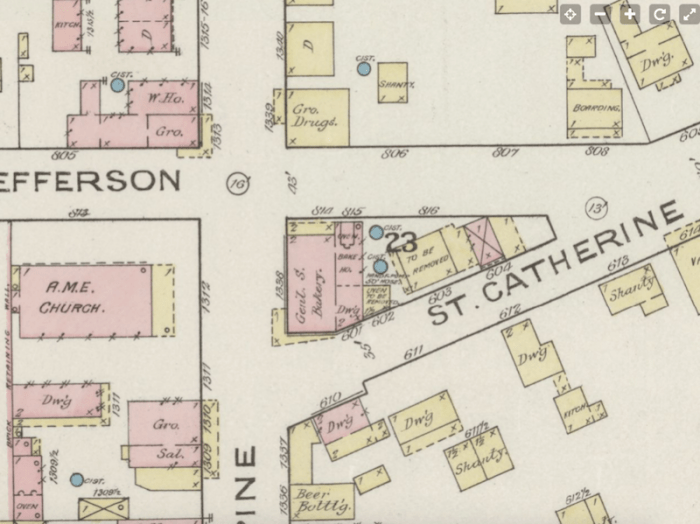
The 1892 Sanborn map shows the bakery at 223 Pine, and the 1892 City Directory for Natchez listed P. Burns at 223 N. Pine. Grocery stores are also on the other 3 corners for Pine/Jefferson, Pine/St. Catherine north and Pine/St. Catherine south.
By October 7, 1920, Alderman C. E. McClure “called attention to the numerous automobile accidents at the Burns triangle in Pine street…” (Natchez Democrat, p. 1), and recommended it be made a one-way drive in a follow-up council meeting October 13.
A ordinance providing that all travel by wheeled vehicles through and over the Westerly end of St. Catherine Street, in the City of Natchez, at what is known as the “Triangle,” where said street enters into Pine Street, shall be in one direction only, namely from West to East; providing penalties for violation and for other purposes. (Natchez Democrat, Oct. 22, 1920, p. 9)
Whether horse-drawn or motor-driven, wheeled vehicles were required to enter Pine Street from “St. Catherine street by way of Jefferson street, extended across Pine Street into St. Catherine street, as will appear by said map.” The current configuration of the Triangle remains the same, with the south side of St. Catherine being one-way from MLKing/Pine to the fork at the apex of the triangle, where it terminates. St. Catherine is one way from beginning to where it terminates at M L King just past the fork of the apex of the triangle on the north side, and becomes Jefferson Street across King.
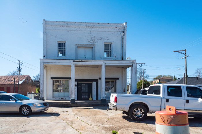
In the Concept Plan for the Downtown Natchez Master Plan, the historic evolution of the MLK Triangle area is presented. The plan includes the same historic photographs on the Natchez Trail (pictured above) as well as additional photographs of the Texaco Service Station, and indicated it was constructed between 1925 and 1950. The Mississippi Department of Archives and History dates the two-story brick building as circa 1926, while the Natchez Trail marker indicates 1940, and that it was constructed from the remains of Homewood, which burned in 1940. Efforts to locate a more precise time based on the newspaper archives did not result in the hoped-for outcome, but did turn up a considerable amount of fascinating history. I am more inclined to think the c. 1926 date is more accurate, given the design of the building, and the location of the Goodyear station in the Triangle in 1930. I can locate no information about the Texaco station, but the vehicle in the historic photo of the station in the Downtown plan appears to be a 1939 Plymouth sedan.


MLK Triangle sub-area includes the Triangle Space, and the goal for that specific space is:
- Convert the “triangle” into a formal public space with green space, plaza, or a combination
- Preserve the Filling Station at the west end and create a trailhead for the St. Catherine Trail
- Include ample space for gathering
- Ideal location for public art or monuments to African American Heritage (Downtown Natchez Master Plan)
 Although plans include establishing the “hub of a Black Cultural Heritage District focused on celebrating African American history and culture,” saving the buildings along M L King between Franklin and St. Catherine is seen as an essential in the plan to link the eastern end of downtown to the MLK Triangle area. Housing, business development, and cultural planning include supporting and enhancing the interpretation of the Rhythm Night Club fire, and to capitalizing on Natchez’s position in part of the Americana Music Triangle–Nashville, Memphis, and New Orleans (Downtown Natchez Master Plan).


Categories: African American History, Antebellum, Gas Stations, Historic Preservation, Natchez

I LOVE, LOVE that service station building!!! One of my favorite commercial buildings in Natchez.
LikeLike
I liked the old photograph that still showed the pumps and the iron balcony railing. I hope they will get moving on that restoration!
LikeLike
Does anyone know of an existing set of blueprints for this building? I’d love to reproduce it on my property.
LikeLike