
I don’t know anything about the “Old Water Grist Mill, near Macon,” which photographer James Butters from the Historic American Building Survey documented in June 1936, and apparently neither does MDAH, since the only mill in Noxubee County they have in their database is a grist mill on Line Street in Shuqualak built around 1930.
The data sheet included with the photos says this mill was built in 1836 by Captain John C. Holmes and that “part of the old machinery is still in use but some new or more modern installed in later years.” I suspect the old gal has long fallen into ruins and returned to dust, but maybe someone out there can tell us more about the place, or at least where it was located?
The second photo is almost a work of art, isn’t it?
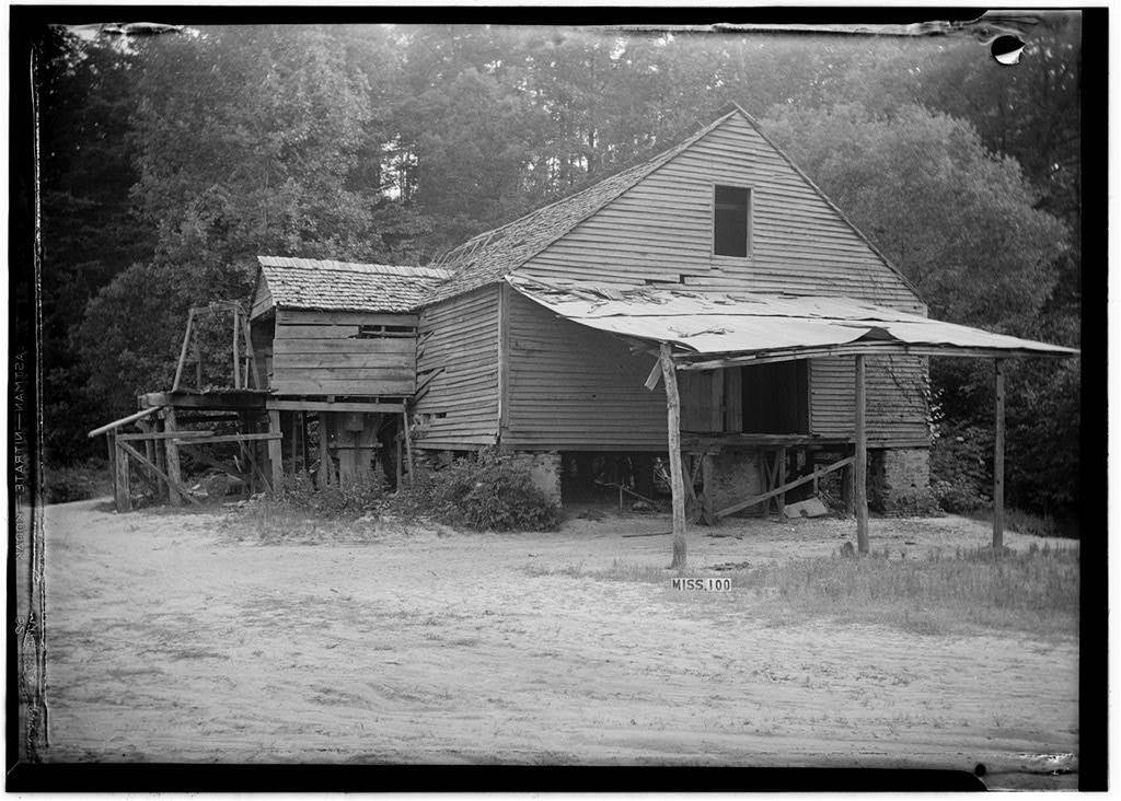
James Butters, HABS Photographer, June 17, 1936 FRONT (NORTH VIEW) – Old Water Power Grist Mill, Macon, Noxubee County, MS
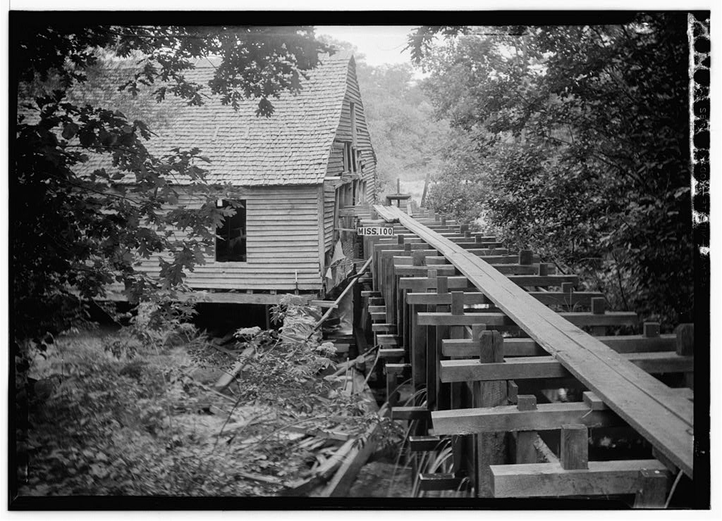
James Butters, HABS Photographer June 17, 1936 REAR (SOUTHWEST CORNER) – Old Water Power Grist Mill, Macon, Noxubee County, MS.


HABS website: http://www.loc.gov/pictures/item/ms0077/
Categories: Industrial, Macon

The Natchez Bulletin, Oct. 15, 1869, p. 2–About seven miles west of Summerville I came upon the Hashuqua Cotton Mills, situated in the most obscure point in Noxubee County. The main building is 200 feet long, 50 feet wide and two stories high. About 1500 spindles are in operation. Only twenty looks are running, but a machinist is busily engaged starting more, and in two months sixty looms will be in operation. The Company was organized about two years ago, with Capt. John C. Holmes of Winston County, as President…The Company…houses for operatives, boarding house, store house, etc. are completed. The machinery is of the most improved English manufacture, and driven by a water-wheel which is a great advance in that line. There is a water-house with 10 1/2 feet of water, and this wheel is at the bottom, out of sight, and does not ripple the surface. The water runs out through the wheel, and has the appearance in emerging, of a large spring. No spray, no foam, and comparatively no noise is made.
Summerville was located about 16 miles from Macon, and in would be in Noxubee County today, according to Roadside Thoughts: A Gazetteer for the United States and Canada.
LikeLiked by 1 person
Hashuqua Creek appears to be a tributary of Noxubee River, and was the likely water source. I found a reference that the land is owned by the Pugh family of Noxubee County since 1968. Obviously, I cannot assume this is the same location as the above mentioned mill, but it may have been related. Holmes’ company (with co-owners) was built in 1866.
LikeLike
There was a gristmill west of Brooksville on the noxubee river also.
i spent my childhood and adult years until I was 50 camping and cutting firewood on the property where the mashullaville (sp)mill was. It was indeed on Hayshuqua Creek,near the headwaters. We Played on the ruins of the mill. We used to camp on the damnitself.
LikeLike
The description of the Hashuqua (locally pronounced “Hay-shooker”) Mill is quite interesting! It certainly makes clear that the mill was powered by a turbine wheel which was apparently the most common type watermill in Mississippi according to geographer Milton Newton in his article on water mills in Amite County. Sciple’s Mill in Kemper County is powered by a turbine.
Several years back along with several others I visited the site of Hashuqua Mill. I remember a remnant of a sizeable dam. Following our field trip the site is now recorded in the state archaeological site files.
It’s possible that the HABS water mill could be located if you could locate the right informants. Otherwise, you could go about it through land title in that the land owner’s name is provided: Dr. J.E. Anderson
Carol Taff just commented to me that the name is suggestive of the Shuqualak vicinity. There will probably be some brick remains and remains of the mudsills in the creek bed.
LikeLiked by 1 person
Regarding the second photo of the HABS mill, the framing made largely of vertical posts would have carried the mill race, i.e. the boxed channel that carried water to the wheel. Other than the post and framing, the race is largely not extant. At the far end of the race one sees what appears to be a vertical metal rod with a wheel near the top. This probably went down into the turbine wheel below, or was parallel to another rod that went into the turbine. When the turbine was activated water flowed through turning the rod or rods which then turned a belt that transmitted the power inside to the mill(s) and very likely a cotton gin. The same power source (i.e. the turbine) could have and often was used to operate more than one machine. Hence mills–both water and steam–often served to operate a grist mill, saw mill, and gin, but not at the same time.
LikeLiked by 1 person
The archaeological documentation at MDAH concerning the large Hashuqua Cotton Factory should include a copy of a photo inherited by the Hubbard family who eventually owned the factory. The period photo was reproduced by MSU’s then photographer Fred Faulk. Documentation at MDAH may also include Mrs. Hubbard’s drawing of the factory, but certainly includes survey information gathered by the archaeologists and others that visited the factory site. All of this information is also found in the Hashuqua Cotton Factory Collection in the MSU Library’s Special Collections, together with research materials concerning the factory and photographs taken during the visit to the factory site. Investors in the factory were from Oktibbeha, Lowndes and Noxubee Counties. Tyson’s Noxubee County history is a good resource for mill information, but is not indexed, although the public library at Macon has a card index that probably covers the Tyson history, since it includes many Noxubee County sources.
LikeLiked by 1 person
I remember it well. I was born and raised in Macon where my father and his partner ran The Macon Beacon, a weekly newspaper. My family and grandparents lived and were raised in Macon. It was a wonderful community and my experience there was great growing up. May friends and I often went down to the waterfall south of town and watch and play around the waterfall
Doug Ferris 601-594-5725
2702 S. Lamar Blvd. Suite 307
Oxford, MS 38655
LikeLike
I went there many times with friends as youngsters growing up in nearby Macon, MS. back in the 1950’s. Great times!
Doug Ferris 601-594-5725
LikeLike